How Google Maps Sees the World
The Evolution of Google Street View
Google Street View has become an essential tool for exploring the world from the comfort of your home. Whether you're trying to get a sense of what your friend's house looks like before visiting or simply want to take a virtual walk through a distant city, Street View has you covered. It even offers glimpses of Antarctica and space, making it one of the most versatile tools available.
Since its launch in 2007, Google has been continuously expanding its coverage. Today, the service includes 12 million miles across 110 countries. This impressive feat is made possible by regular updates and the use of various data collection methods. While many people are familiar with the iconic Street View cars, the company also uses satellites, planes, and even individuals to capture images. The real innovation lies in its camera system, which has evolved significantly over the years.
The Camera That Captured the World
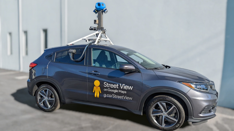
The original Street View camera was a massive 500-pound device that required a forklift to mount on a Chevrolet Astro van. Over the years, the technology has advanced dramatically, leading to the current model introduced in 2022. This version weighs just 15 pounds, allowing it to be mounted on almost any vehicle with a roof rack. This flexibility has enabled Google to hire contract drivers to traverse the world’s roads, collecting vast amounts of data.
The cameras feature seven 20-megapixel sensors and are connected to a bank of computers that store not only images but also location data, speed, and direction. These computers are later transported to one of three Street View hubs located in North America, Asia, and Europe. The collected information is then processed to create panoramic views of specific locations, forming the navigable service we all know today.
Camera Carriers: Beyond the Road
While cars have been the primary means of capturing images, there are many places where vehicles cannot go. To address this, Google has used a variety of unconventional carriers. From camels in the harshest deserts to boats in swampy waterways, the company has found innovative ways to reach remote areas. Snowmobiles, scuba divers, and human-powered trikes have all been used to capture images in challenging environments.
On the Faroe Islands, where sheep outnumber people, the animals were even put to work for Google. In a more extreme example, astronauts have taken custom rigs to the International Space Station, allowing users to explore space via Street View. Additionally, push-cart trolleys have been used to access museums and other restricted areas.
Hikers and Volunteers: The Human Element
For the most difficult-to-reach locations, Google relies on human effort. Hikers have carried the backpack-mounted Trekker system to places like Machu Picchu, Antarctica, and even the interior of a volcano. One individual went as far as space, with astronaut Thomas Pesquet taking a custom rig to the International Space Station.
Beyond these efforts, Google also enlists volunteers. Anyone can purchase a compatible camera, mount it on their vehicle, and upload images to Street View Studio. This community-driven approach helps Google update its coverage for areas it might not otherwise reach.
Expanding Coverage with Third-Party Sources
Google’s Street View project is not solely reliant on its own efforts. The company collaborates with thousands of third-party sources, including local governments and satellite providers. This allows for a broader range of images and ensures that even the most remote areas can be explored virtually.
Despite its extensive coverage, there are still some regions that remain inaccessible. The deepest deserts, tundras, central Africa, and much of eastern Russia are not fully covered. However, Google continues to push the boundaries of what is possible, using its advanced camera systems and diverse transportation methods to capture the world.
Conclusion
From its humble beginnings as a heavy, cumbersome device to its current state as a lightweight, versatile tool, Google Street View has come a long way. With the help of innovative technology, a global network of drivers, and the contributions of volunteers, it has transformed how we explore the world. Whether you're planning a trip or simply curious about a distant location, Street View offers an incredible way to experience the planet from anywhere.